
Across a vast desert plateau, ancient lines awaken under modern eyes. In months, researchers doubled known figures once hidden in plain earth. They paired fieldwork with Artificial Intelligence, which spots faint patterns people miss. The result opens a deeper reading of geometry, ritual, and landscape. Here is how the puzzle shifted, why it matters, and what comes next. Numbers, methods, and meaning fit together, while caution still guides every step. The picture is clearer, yet far from complete.
A century of watching the desert from above
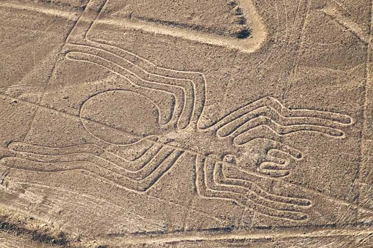
For decades, scholars traced Nazca Lines from planes and on foot. These desert geoglyphs date from 200 BC to 650 AD. They form animals, plants, and sharp geometry etched into pale ground. UNESCO recognizes the site for scale and technical mastery. Some stretch hundreds of meters yet keep crisp edges.
Within six months, a Yamagata University and IBM team doubled known figures. They reported 303 previously unknown geoglyphs, published in PNAS, and confirmed by Prof. Masato Sakai. Many remained invisible because the desert is immense and surveys are slow. Old methods missed faint lines among wind scars and overlapping tracks.
The new forms show symmetry across big distances, implying advanced spatial planning. Zoomed images reveal cats, birds, fish, and abstract shapes arranged with care. With Artificial Intelligence, the catalogue expanded while human teams confirmed each site. Context on the ground protects meaning from false patterns and noise.
How Artificial Intelligence accelerated Nazca mapping
Engineers trained detection models on thousands of aerial photos capturing subtle contrasts. Computer vision learned edges, curves, and junctions shaped by human hands. It flagged potential geoglyphs across terabytes of satellite and drone imagery. The pipeline prioritized candidates for field surveys, then logged confidence and location automatically.
Speed came from scale and pattern memory built during training. Because Artificial Intelligence scans every pixel without fatigue, faint lines emerge early. A human would miss many candidates, while the model never blinks. Researchers still decided thresholds, refined labels, and resolved confusing overlaps on complex surfaces under intense light.
Every flagged site needed boots, notes, and context on the ground. Teams measured grooves, checked erosion, and linked paths to nearby features. Only then could drawings join the official record with coordinates and photos. The loop kept precision high, while false positives fell with each pass over many zones.
What the new figures likely meant on the ground
Patterns cluster near routes, watercourses, and vantage points across the plateau. Researchers see processional paths shaped for ceremony and seasonal movement. Walking the lines may have joined people with landscape and sky. Orientation and scale suggest coordinated gatherings rather than isolated art across wide corridors over many generations here.
Maria Reiche documented exact geometry and alignments long before today’s datasets. Her maps showed planning, rhythm, and symmetry that rules still explain. New figures reinforce that design language, now traced at greater resolution. Meaning arises when shapes connect to routes, seasons, and nearby landmarks, not distant stars.
While Artificial Intelligence reveals candidates, ritual logic tests whether lines hold. Teams walk segments, watch erosion, and compare footprints with expected wear. If paths read as journeys, clusters and gateways often appear nearby. This grounded reading keeps myths tempting, yet evidence-led and cautious through every decision made.
Limits and safeguards when Artificial Intelligence meets fieldwork
Models confuse wind scars, tracks, and modern scrapes with human designs. Researchers like Dr. Alexandra Karamitrou from the University of Southampton stress that systems err, especially on edges. That is why teams revisit sites and adjust labels as terrain changes. The discipline remains conservative, because archives carry long memories and reputations.
Field verification slows fast pipelines, yet protects trust and shared heritage. Teams treat Artificial Intelligence as a partner that ranks, not a judge that rules. Photogrammetry, GPS surveys, and soil notes temper automated claims. When models improve, confidence rises, and false positives fall further across test zones.
Speed matters because tires, storms, and sprawl erase shallow grooves. By triaging areas, teams protect fragile corridors before marks vanish. Priority maps help guardians plan closures and signage that guide walkers. Knowledge grows while the landscape remains readable for future visitors and researchers worldwide during dry seasons.
A broader shift reshaping archaeological discovery worldwide
Similar pipelines now search forests for settlement traces under canopy. Algorithms map burial mounds in Europe and locate hidden harbors offshore. Maritime teams cross-match sonar with old charts to pinpoint likely wrecks. Patterns, once faint, become candidates people can test on site with faster budgets and focused crews.
At Saruq Al Hadid in the United Arab Emirates, satellite analysis mapped artifact clusters. Teams prioritized trenches where distribution patterns suggested activity zones. Work began faster because logistics, permits, and labor synced with data-led plans. Ground results refined models, then sent crews to stronger targets later that season.
Dr. João Fonte of ERA Arqueologia calls the shift a leap in efficiency, measured in days. Surveys once lasted years, yet schedules now compress without losing rigor. The mix of field skills and Artificial Intelligence unlocks landscapes while budgets stay realistic. That balance keeps quality high, so institutions back bolder mapping.
Why these lines still matter as models and memories endure
Each new figure brings craft, movement, and belief into sharper view. As records grow, preservation choices improve, and empty myths fade. Because teams pair ground truth with Artificial Intelligence, speed no longer costs care. We read continuity across centuries while protecting fragile corridors from harm. This is not an ending, but a clearer beginning for responsible discovery. Future models will learn faster as verified datasets expand and diversify. With patience, more pathways will surface, and more stories will survive.