
A slow force beneath Africa is reshaping the map, and the signs feel closer than before. Scientists tracking ground motion, quakes, and heat flows describe a continental scar stretching for thousands of kilometers. Satellite eyes confirm the trend as valleys widen and faults creep. The idea of a new ocean sounds distant, yet evidence stacks up. While the timeline spans millions of years, the process moves today. People already live with it, build over it, and draw power from it.
Rift basics, plates in motion, and a growing scar
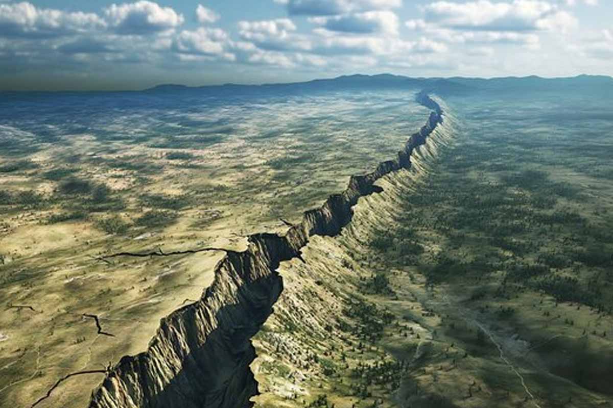
The East African Rift extends more than 3,000 kilometers, from Ethiopia’s Afar Triangle through Kenya and Tanzania to Mozambique. Africa’s crust thins here because deep forces pull the land apart. Geologists say the African Plate splits into the Nubian Plate on the west and the Somali Plate on the east.
Those same forces once tore Africa and South America apart, so the comparison feels natural. The rift opens by a few millimeters each year, which sounds tiny, yet time multiplies small steps. Valleys sink as magma rises. The rock stretches until it finally cracks, as stress shifts and spreads along faults that run through the crust like seams.
They track the changes by combining satellite images, field observations, and years of seismic research. They see patterns grow clearer as instruments improve. The science suggests a faster pace than earlier models, not fast in human terms, but brisk in geologic time. The vision of a new ocean belongs to deep time, yet its roots lie in the present.
How a new ocean starts along a living rift
A rift works in stages because Earth sheds stress in bursts. First, the crust stretches and thins. Magma intrudes as sheets. Then faults step outward and lengthen. When blocks drop, basins form. Water gathers where rock subsides, while heat builds below. The cycle repeats as stress reloads.
Edges do not move evenly, so the rift zigzags along weak zones. Segments link up over ages. The process acts like a slow zipper, with volcanic intrusions marking progress inside the crust. Each intrusion pries rock apart. Pressure drives fluids through fractures. Heat alters minerals because circulation reshapes the deep plumbing.
Scientists compare these steps with the early Atlantic because the script rhymes. The mechanics differ in detail, yet the arc remains. Stretch. Thin. Break. Then widen. The crust fails in pieces. Mantle upwelling steadies the pace while magma feeds the rift. Oceans begin this way, inside land, long before waves arrive.
Surface clues from Kenya to the Afar Depression
The land already speaks. In 2018, a long fissure opened in southwestern Kenya and cut through roads and farms. Heavy rain exposed it, yet deeper movement mattered. The split traced a tectonic line because stress had weakened the ground. Repairs patched the surface; the strain remained below.
Farther north, the Afar Depression meets the Red Sea and the Gulf of Aden. Three plates diverge at this triple junction. Quakes and eruptions mark the zone because magma rises near the surface. New crust forms as lava cools. The ground drops, then grows a crustal scar that guides future breaks.
NASA imagery shows rift valleys lengthen while fractures multiply. Each satellite pass adds pixels to a time-lapse. Patterns emerge as lines brighten and widen. The landscape records strain because rocks respond to pull and heat. Each crack and fault hints at a new ocean, only one patient step further on.
Timelines, rates, and the slow birth of seas
The rift widens at millimeter-scale rates, yet those rates add up. Over millions of years, basins deepen and connect. Water finds the lowest path because gravity never tires. The Red Sea and the Gulf of Aden could one day invade the rift, linking distant valleys into a single flooded chain.
Some scientists frame that horizon at five to ten million years. The window stretches because Earth moves in fits and starts. Heat flow pulses. Faults stall, then slip. New segments awaken while old ones fade. Models evolve with data because instruments sharpen our view. Pace and pattern grow clearer over time.
Geophysicist Christopher Scholz says East Africa offers a rare chance to watch a continent split apart in real time. It’s a striking view because it’s happening on land, right before our eyes, instead of hidden beneath the ocean. The stage shows stress, magma, and motion at work. From that vantage, the earliest shape of a new ocean looks less abstract.
What a new ocean could mean for people and power
Geology meets daily life along the rift. Quakes rattle towns, and ground instability complicates roads, pipes, and buildings. Engineers weigh fault maps during design because shifting ground can tilt foundations. Farmers adjust as soil slumps or cracks. Risk planning grows vital where stress loads concentrate.
Volcanism also brings heat that can be used. Kenya already taps geothermal fields to power its grid. Hot water drives turbines. Steam replaces fossil fuel because heat rises regardless of weather. Energy planners like baseload output that runs at night and in storms. Communities benefit when stable power reaches homes and clinics.
Future flooding could cut off a vast stretch of land, taking in parts of Ethiopia, Kenya, Tanzania, and Mozambique. The split would echo Madagascar’s separation, though the path differs. Maps would redraw coastlines. Shipping routes might adapt. Borders respond more slowly than waves, yet people plan as hints become patterns.
Why this long tectonic story matters to us now
The rift tells a human story because change shapes choices. People live on the faulted ground, work near vents, and harvest heat from below. The science points to a new ocean, yet the present needs steady roads, safer homes, and smart grids. Planning today meets a planet that moves.